A little bike parking inspiration today, Multnomah University just installed single-side Bike Lockers and our sleek Burnside Bike Corrals for a great multi-function long-term – short-term bike parking combo.
multimodal bike lockers are easily secured with padlocks or U-Locks
The Burnside Bike Corral is easily installed on cement surfaces with anti-theft bolts
Bike lockers and corrals make a great multi-use space
Ready for the new school year with plenty of bike parking!
The most important bike route improvements currently happening in Portland, part 2
We recently published part one of this post—you can read that here. Today we’re highlighting one more of our favorite new infrastructure developments currently underway in Portland, and closing out this two-part discussion with an international example of carless infrastructure that combines ingenuity, sustainability, functionality and environmental considerations to really shift the thinking on the relationship between roads, ped/bike paths, and the natural world.
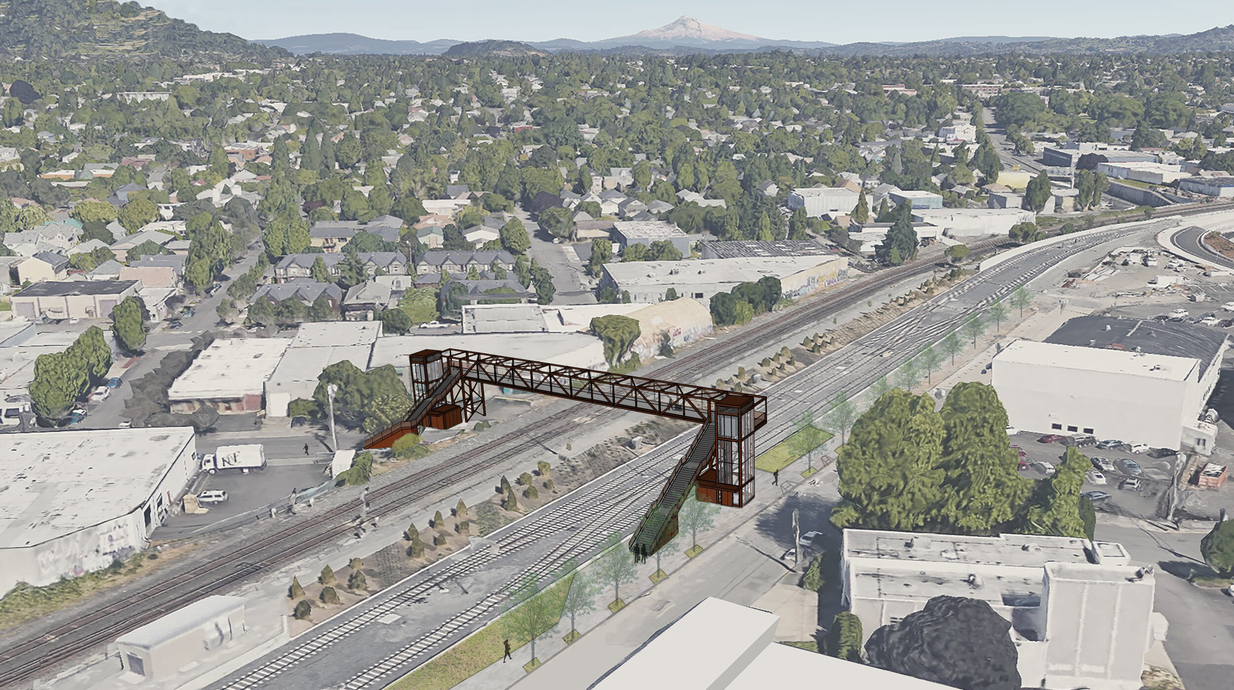
Gideon Overcrossing
Conceptual renderings courtesy of Trimet
WHAT IT IS
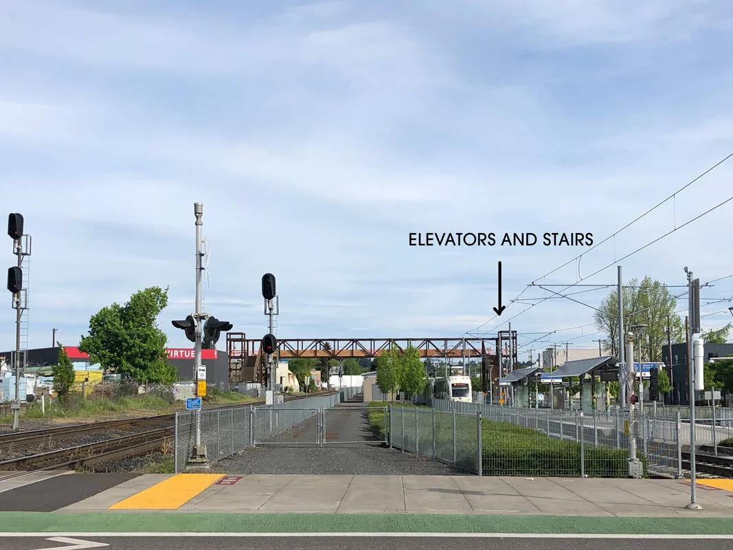
This bike and pedestrian crossing is being constructed over the MAX Orange line and Union Pacific Railroad tracks, connecting SE 14th Avenue and SE 13th Place at Gideon Street.
This is notoriously one of the worst places in Portland to get stuck at a crossing, with freight trains sometimes resting at a full stop across the intersection for up to two hours. While this bridge can’t help those poor souls in cars, it will be equipped with stairs and elevators on both sides to ferry cyclists and pedestrians safely across. A former crossing had to be removed during the construction of the Orange Line, and this return has been a long time coming. Currently your best bet for getting across the tracks is at SE Milwaukie Ave., where it splits into 11th and 12th. But, again, stopped trains are an issue. Cyclists are often seen climbing over the couplings of active freight cars—what? People. Let’s please stop doing this. Delays are such a pain point to commuters and businesses alike that a development group in a nearby building built a uni-functional website specifically to track whether or not a train is blocking the intersection. At press time, isatrainblocking11th.com reported: “NO.”
WHY IT’S IMPORTANT
This crossing will unite the busy greenways of Gideon Street and Clinton Street, and give cyclists an alternative to climbing between railcars (again, let’s don’t) or waiting endlessly for the intersection to be clear. It will also effectively finish off the Clinton to the River project, a mostly-complete 2.8-mile bicycle route that’s been in the works for nearly a decade. Another example of Portland’s ongoing commitment to reshaping how the city handles vehicles, bicycles, and the relationship between the two.
Bonus! The Blauwe Loper Bridge
Screenshot from Blauwe Loper concept video
While Portland keeps finding new ways to route bike and pedestrian traffic across bodies of water, through wildlife preserves, and over busy roadways, the Netherlands recently began construction on a bridge that will span all three, and more. There’s so much to love about this project we’re not sure where to start.
The Blauwe Loper—or “Blue Carpet”—will be the longest bike/ped bridge in Europe and one of the longest in the world. At completion of phase one it will span 800 meters, with plans to ultimately extend it to more than a kilometer. (Technically, China’s Bicycle Skyway holds the title, knifing through the congested core of Xiamen and clocking an impressive 7.6 km—almost 5 miles—of continuous dedicated bike lanes. It’s arguably more of an elevated bicycle highway than a true bridge, but who are we to argue.)
This news should come as no surprise; in the Netherlands, bicycling is a universally-enjoyed pastime and primary form of transportation. It’s often reported that there are more bicycles than people in the Netherlands, and over 32,000 km (about 20,000 miles) of dedicated bike path crisscross the region’s mostly-flat terrain, making it the perfect setting for a bike-first culture.
Just wait, it gets better.
Tantamount to pedestrians and bicyclists, one of the top design considerations for the bridge was a much longer-tenured inhabitant of the region: bats. The Blauwe Loper will be painted a “bat-friendly” green and outfitted with solar-powered LEDs, as an aid for bat colonies to avoid the bridge and navigate from their habitat in a nearby park to the feeding grounds at Oldambtmeer lake and back home again.
Lastly, builders of the Blauwe Loper claim that the structure, built mostly of resilient Central African hardwood sourced in Gabon, will last at least 80 years. As project leader Reinder Lanting told a local daily newspaper, “This bridge is not going to rot. That is because it is technically well designed. The wood is not pressed together but has a sort of venting system.”
We love the ingenuity and radical thinking at work here. You can learn more about the project at Blauwestad.com.
As we said in part one of this post, follow the progress of these projects online, go check them out in person, and use them when they’re completed. Take advantage of pedestrian and bicycle infrastructure to get out and enjoy Portland, or Blauwestad, or wherever you’re reading this from. We’ll see you out there.
The most important bike route improvements currently happening in Portland, part 1
The City of Portland is constantly working to improve traffic flows, making it easier for all of us to get where we’re going. You can spot efforts across the city marked by bright-green painted lanes and cute little bicycle-shaped traffic signals that remind us of novelty pasta. But the net effect is much larger than these individual efforts. Each new bicycle lane and neighborhood greenway represents the effort to reduce carbon emissions and encourage active forms of transportation. We think that’s worth celebrating. In this two-part post, we’re highlighting some of our favorite projects currently in the works: three new carless bridges in Portland (plus a bonus bridge in the Netherlands!) that represent an easier way to get across town on two wheels, and much more.
Congressman Earl Blumenauer Bridge
Conceptual renderings courtesy of Portland Bureau of Transportation
WHAT IT IS
Also known as Sullivan Crossing, the bridge’s official name honors the bowtie-sporting bicycle-championing civil servant who’s been lobbying for its existence for decades. The bridge will span Interstate 84 at NE Seventh Avenue, connecting the Lloyd and Central Eastside Industrial districts.
The Blumenauer Bridge is part of Portland’s Green Loop initiative, an ambitious plan to create six miles of connected park space through the heart of the city. The Green Loop is designed to provide access to local businesses and services by foot, bike or mobility device (like e-scooters). The Green Loop is a tangible symbol of Portland's commitment to improving access to parks, nature, and alternative transportation, and this bridge will be a linchpin of that effort. You can check out an earlier post we published on the Green Loop here.
WHY IT’S IMPORTANT
Anyone who walks or bikes in the area knows how desperately this solution is needed. Currently, your best route over the interstate is the NE 12th overpass, a heavily-trafficked stretch of pocked pavement. Other options are the MLK and Grand Avenue connections that make up 99E—literally a highway. Less than ideal.
With plenty of bike lanes and neighborhood greenways weaving their way through the inner-eastside, this bridge feels like the missing link and a welcomed addition to the area. Ground has been broken and construction is slated for completion in the spring of 2021. The bridge will be 24 feet wide to accommodate emergency response vehicles if necessary. It will feature a 10-foot pedestrian path, a 14-foot two-way bicycle track and, according to Commissioner Chloe Eudaly, “come hell or high water, somewhere on this bridge, there will be a bow tie.” We love that.
Flanders Crossing
Conceptual renderings courtesy of Portland Bureau of Transportation
WHAT IT IS
In an equally crucial move, this new bike and pedestrian bridge will span Interstate 405 at NW Flanders Street, linking Nob Hill and the Alphabet District to the Pearl.
Not only does this project consist of a carless bridge over the 405, it’s become part of a larger effort known as the Flanders Bikeway. In total, the Bikeway is planned to transform NW Flanders Street from 24th all the way to Naito Parkway, including the Crossing. Bike and pedestrian traffic will be prioritized while vehicle flow is limited to discourage cut-through traffic. The project has loomed on the City of Portland’s radar for years, stuck in priority purgatory, but construction is finally slated to begin this year. If it’s done well, this project can act as a blueprint and a catalyst for Portland to prioritize alternative modes of transportation across the city.
WHY IT’S IMPORTANT
Currently the best way to cross the 405 by bike in that area is Everett Street (heading east) and Glisan (going west). The two overpasses make up the heart of a busy freeway ramp network, and even with improvements over the last few years, neither offers much in the way of bike or ped facilities. With initiatives like Better Naito Forever and the previously-mentioned Green Loop also in the works, the bridge and bikeway can connect retail, dining and professional offices in Northwest to the Waterfront and the rest of the city.
Track the progress of these projects online, go see them in person, and make use of them when they’re completed. We certainly plan to.
In the meantime, keep an eye out for part two of this post, which will cover another important Portland project plus some bonus international bike news!
A Brief Aside
We’re in the middle of a global pandemic. There’s plenty of discussion happening on the subject and we don’t feel like it’s our place to weigh in. We want to applaud healthcare professionals and essential workers, and thank everyone for doing their part to help us all get through this.